
SSURGO Soil
The SURGGO Soils API provides soil type and average of the soil type attribute (e.g., NCCPI) by field for a shape entered.
b) GET Request SSURGO Soils
Please note, this API has been deprecated. Please use the new version.
This API is utilized to drive the Ag-Analytics SSURGO soil panel below, for illustration. Area calculations from the API are provided in square meters and can be easily converted to acres on the front-end. The API Response contains shapes/features in ESRI JSON format, as well as the calculated metric (e.g., National Commodity Crop Productivity Index) and areas of each shape, the soil type name, the area for the sums of each soil type across all features for display in the table, metadata related to projection and other information. This API can be easily called and mapped using any standard front-end JavaScript mapping library (e.g., Leaflet).
Please note, we will gradually transition to the SSURGO Soil v2 API, which features changes in the response. Changes will be reflected in the SSURGO Soil v2 API Documentation and Jupyter Notebook.
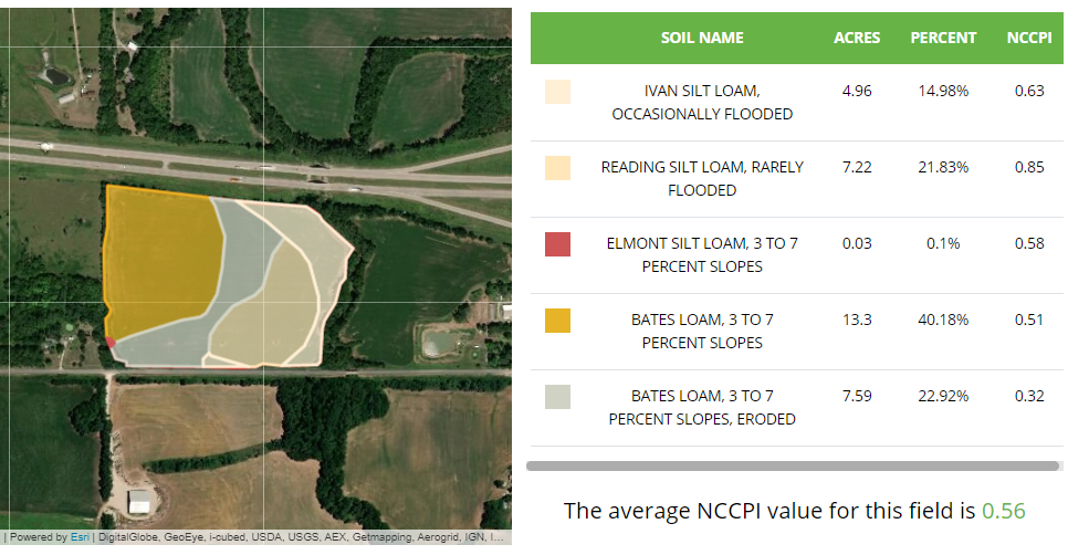
SSURGO Soils and NCCPI in Ag-Analytics FarmScope.


Click the Jupyter Notebook Static Sample to view a static rendition of this APIs Jupyter Notebook.
Click the Jupyter Notebook Github Repo to access the Jupyter Notebook .ipynb files and
instructions needed in order to run this APIs Jupyter Notebook.
Request Parameters
| Parameter | Data Type | Required? | Default | Options | Description |
|---|---|---|---|---|---|
| inputShape | Esri Geometry | Yes | -- | See esriGeometryType Constants |
The shape information for the field, as an Esri Geometry object |
| inputFields | String | Yes | aws0_5 | See full NRCS list |
The soil metric to return, see the NRCS variables PDF for full list with descriptions. |
| f | String | Yes | json | json/pjson | Response format. |
| spatialReference WKID |
Number | Yes | 4326 | See WKID list | The well-known ID of the desired spatial reference. |
Call API
Request
Request URL
Request parameters
-
(optional)
ESRI Polygon shape.
The inputShape should have the Albers (“wkid”: 5070) spatial reference. The shape information for field is esriGeometryPolygon format. Standard open source JavaScript front-end libraries (e.g., Leaflet) can be used to structure the shape. See example request below, in which "spatialReference": {"wkid": 5070} is required
Request headers
-
string
Request body
Responses
200 OK
Code samples
@ECHO OFF

curl -v -X GET "https://ag-analytics.azure-api.net/ssurgosoil/get?inputShape={"geometryType":"esriGeometryPolygon","features":[{"geometry":{"rings":[[[-89.311086,40.265971],[-89.311026,40.263477],[-89.310869,40.263278],[-89.310224,40.263128],[-89.309801,40.262867],[-89.309497,40.262679],[-89.309505,40.262575],[-89.309495,40.262428],[-89.309569,40.262531],[-89.309731,40.262713],[-89.309836,40.262822],[-89.310014,40.262919],[-89.310352,40.26294],[-89.310478,40.262921],[-89.310486,40.262918],[-89.310609,40.26285],[-89.310749,40.262749],[-89.31075,40.262678],[-89.310776,40.26254],[-89.310749,40.262326],[-89.310746,40.260049],[-89.310769,40.259843],[-89.311024,40.259747],[-89.311049,40.259724],[-89.311091,40.259688],[-89.311124,40.259555],[-89.311195,40.259451],[-89.311238,40.259423],[-89.311312,40.259368],[-89.311416,40.259366],[-89.313941,40.259364],[-89.314001,40.259364],[-89.314079,40.259336],[-89.314127,40.259293],[-89.314186,40.259196],[-89.314285,40.265951],[-89.311204,40.265976],[-89.311086,40.265971]]],"spatialReference":{"wkid":4326}}}]}&inputFields=nccpi2all"
-H "Ocp-Apim-Subscription-Key: {subscription key}"

--data-ascii "{body}"
using System;
using System.Net.Http.Headers;
using System.Text;
using System.Net.Http;
using System.Web;

namespace CSHttpClientSample
{
    static class Program
    {
        static void Main()
        {
            MakeRequest();
            Console.WriteLine("Hit ENTER to exit...");
            Console.ReadLine();
        }

        static async void MakeRequest()
        {
            var client = new HttpClient();
            var queryString = HttpUtility.ParseQueryString(string.Empty);

            // Request headers
            client.DefaultRequestHeaders.Add("Ocp-Apim-Subscription-Key", "{subscription key}");

            // Request parameters
            queryString["inputShape"] = "{"geometryType":"esriGeometryPolygon","features":[{"geometry":{"rings":[[[-89.311086,40.265971],[-89.311026,40.263477],[-89.310869,40.263278],[-89.310224,40.263128],[-89.309801,40.262867],[-89.309497,40.262679],[-89.309505,40.262575],[-89.309495,40.262428],[-89.309569,40.262531],[-89.309731,40.262713],[-89.309836,40.262822],[-89.310014,40.262919],[-89.310352,40.26294],[-89.310478,40.262921],[-89.310486,40.262918],[-89.310609,40.26285],[-89.310749,40.262749],[-89.31075,40.262678],[-89.310776,40.26254],[-89.310749,40.262326],[-89.310746,40.260049],[-89.310769,40.259843],[-89.311024,40.259747],[-89.311049,40.259724],[-89.311091,40.259688],[-89.311124,40.259555],[-89.311195,40.259451],[-89.311238,40.259423],[-89.311312,40.259368],[-89.311416,40.259366],[-89.313941,40.259364],[-89.314001,40.259364],[-89.314079,40.259336],[-89.314127,40.259293],[-89.314186,40.259196],[-89.314285,40.265951],[-89.311204,40.265976],[-89.311086,40.265971]]],"spatialReference":{"wkid":4326}}}]}";
            queryString["inputFields"] = "nccpi2all";
            var uri = "https://ag-analytics.azure-api.net/ssurgosoil/get?" + queryString;

            var response = await client.GetAsync(uri);
        }
    }
}
// // This sample uses the Apache HTTP client from HTTP Components (http://hc.apache.org/httpcomponents-client-ga/)
import java.net.URI;
import org.apache.http.HttpEntity;
import org.apache.http.HttpResponse;
import org.apache.http.client.HttpClient;
import org.apache.http.client.methods.HttpGet;
import org.apache.http.client.utils.URIBuilder;
import org.apache.http.impl.client.HttpClients;
import org.apache.http.util.EntityUtils;
public class JavaSample
{
public static void main(String[] args)
{
HttpClient httpclient = HttpClients.createDefault();
try
{
URIBuilder builder = new URIBuilder("https://ag-analytics.azure-api.net/ssurgosoil/get");
builder.setParameter("inputShape", "{"geometryType":"esriGeometryPolygon","features":[{"geometry":{"rings":[[[-89.311086,40.265971],[-89.311026,40.263477],[-89.310869,40.263278],[-89.310224,40.263128],[-89.309801,40.262867],[-89.309497,40.262679],[-89.309505,40.262575],[-89.309495,40.262428],[-89.309569,40.262531],[-89.309731,40.262713],[-89.309836,40.262822],[-89.310014,40.262919],[-89.310352,40.26294],[-89.310478,40.262921],[-89.310486,40.262918],[-89.310609,40.26285],[-89.310749,40.262749],[-89.31075,40.262678],[-89.310776,40.26254],[-89.310749,40.262326],[-89.310746,40.260049],[-89.310769,40.259843],[-89.311024,40.259747],[-89.311049,40.259724],[-89.311091,40.259688],[-89.311124,40.259555],[-89.311195,40.259451],[-89.311238,40.259423],[-89.311312,40.259368],[-89.311416,40.259366],[-89.313941,40.259364],[-89.314001,40.259364],[-89.314079,40.259336],[-89.314127,40.259293],[-89.314186,40.259196],[-89.314285,40.265951],[-89.311204,40.265976],[-89.311086,40.265971]]],"spatialReference":{"wkid":4326}}}]}");
builder.setParameter("inputFields", "nccpi2all");
URI uri = builder.build();
HttpGet request = new HttpGet(uri);
request.setHeader("Ocp-Apim-Subscription-Key", "{subscription key}");
// Request body
StringEntity reqEntity = new StringEntity("{body}");
request.setEntity(reqEntity);
HttpResponse response = httpclient.execute(request);
HttpEntity entity = response.getEntity();
if (entity != null)
{
System.out.println(EntityUtils.toString(entity));
}
}
catch (Exception e)
{
System.out.println(e.getMessage());
}
}
}
<!DOCTYPE html>
<html>
<head>
    <title>JSSample</title>
    <script src="http://ajax.googleapis.com/ajax/libs/jquery/1.9.0/jquery.min.js"></script>
</head>
<body>

<script type="text/javascript">
    $(function() {
        var params = {
            // Request parameters
            "inputShape": "{"geometryType":"esriGeometryPolygon","features":[{"geometry":{"rings":[[[-89.311086,40.265971],[-89.311026,40.263477],[-89.310869,40.263278],[-89.310224,40.263128],[-89.309801,40.262867],[-89.309497,40.262679],[-89.309505,40.262575],[-89.309495,40.262428],[-89.309569,40.262531],[-89.309731,40.262713],[-89.309836,40.262822],[-89.310014,40.262919],[-89.310352,40.26294],[-89.310478,40.262921],[-89.310486,40.262918],[-89.310609,40.26285],[-89.310749,40.262749],[-89.31075,40.262678],[-89.310776,40.26254],[-89.310749,40.262326],[-89.310746,40.260049],[-89.310769,40.259843],[-89.311024,40.259747],[-89.311049,40.259724],[-89.311091,40.259688],[-89.311124,40.259555],[-89.311195,40.259451],[-89.311238,40.259423],[-89.311312,40.259368],[-89.311416,40.259366],[-89.313941,40.259364],[-89.314001,40.259364],[-89.314079,40.259336],[-89.314127,40.259293],[-89.314186,40.259196],[-89.314285,40.265951],[-89.311204,40.265976],[-89.311086,40.265971]]],"spatialReference":{"wkid":4326}}}]}",
            "inputFields": "nccpi2all",
        };

        $.ajax({
            url: "https://ag-analytics.azure-api.net/ssurgosoil/get?" + $.param(params),
            beforeSend: function(xhrObj){
                // Request headers
                xhrObj.setRequestHeader("Ocp-Apim-Subscription-Key","{subscription key}");
            },
            type: "GET",
            // Request body
            data: "{body}",
        })
        .done(function(data) {
            alert("success");
        })
        .fail(function() {
            alert("error");
        });
    });
</script>
</body>
</html>
#import <Foundation/Foundation.h>

int main(int argc, const char * argv[])
{
    NSAutoreleasePool * pool = [[NSAutoreleasePool alloc] init];

    NSString* path = @"https://ag-analytics.azure-api.net/ssurgosoil/get";
    NSArray* array = @[
                         // Request parameters
                         @"entities=true",
                         @"inputShape={"geometryType":"esriGeometryPolygon","features":[{"geometry":{"rings":[[[-89.311086,40.265971],[-89.311026,40.263477],[-89.310869,40.263278],[-89.310224,40.263128],[-89.309801,40.262867],[-89.309497,40.262679],[-89.309505,40.262575],[-89.309495,40.262428],[-89.309569,40.262531],[-89.309731,40.262713],[-89.309836,40.262822],[-89.310014,40.262919],[-89.310352,40.26294],[-89.310478,40.262921],[-89.310486,40.262918],[-89.310609,40.26285],[-89.310749,40.262749],[-89.31075,40.262678],[-89.310776,40.26254],[-89.310749,40.262326],[-89.310746,40.260049],[-89.310769,40.259843],[-89.311024,40.259747],[-89.311049,40.259724],[-89.311091,40.259688],[-89.311124,40.259555],[-89.311195,40.259451],[-89.311238,40.259423],[-89.311312,40.259368],[-89.311416,40.259366],[-89.313941,40.259364],[-89.314001,40.259364],[-89.314079,40.259336],[-89.314127,40.259293],[-89.314186,40.259196],[-89.314285,40.265951],[-89.311204,40.265976],[-89.311086,40.265971]]],"spatialReference":{"wkid":4326}}}]}",
                         @"inputFields=nccpi2all",
                      ];

    NSString* string = [array componentsJoinedByString:@"&"];
    path = [path stringByAppendingFormat:@"?%@", string];

    NSLog(@"%@", path);

    NSMutableURLRequest* _request = [NSMutableURLRequest requestWithURL:[NSURL URLWithString:path]];
    [_request setHTTPMethod:@"GET"];
    // Request headers
    [_request setValue:@"{subscription key}" forHTTPHeaderField:@"Ocp-Apim-Subscription-Key"];
    // Request body
    [_request setHTTPBody:[@"{body}" dataUsingEncoding:NSUTF8StringEncoding]];

    NSURLResponse *response = nil;
    NSError *error = nil;
    NSData* _connectionData = [NSURLConnection sendSynchronousRequest:_request returningResponse:&response error:&error];

    if (nil != error)
    {
        NSLog(@"Error: %@", error);
    }
    else
    {
        NSError* error = nil;
        NSMutableDictionary* json = nil;
        NSString* dataString = [[NSString alloc] initWithData:_connectionData encoding:NSUTF8StringEncoding];
        NSLog(@"%@", dataString);

        if (nil != _connectionData)
        {
            json = [NSJSONSerialization JSONObjectWithData:_connectionData options:NSJSONReadingMutableContainers error:&error];
        }

        if (error || !json)
        {
            NSLog(@"Could not parse loaded json with error:%@", error);
        }

        NSLog(@"%@", json);
        _connectionData = nil;
    }

    [pool drain];

    return 0;
}
<?php
// This sample uses the Apache HTTP client from HTTP Components (http://hc.apache.org/httpcomponents-client-ga/)
require_once 'HTTP/Request2.php';

$request = new Http_Request2('https://ag-analytics.azure-api.net/ssurgosoil/get');
$url = $request->getUrl();

$headers = array(
    // Request headers
    'Ocp-Apim-Subscription-Key' => '{subscription key}',
);

$request->setHeader($headers);

$parameters = array(
    // Request parameters
    'inputShape' => '{"geometryType":"esriGeometryPolygon","features":[{"geometry":{"rings":[[[-89.311086,40.265971],[-89.311026,40.263477],[-89.310869,40.263278],[-89.310224,40.263128],[-89.309801,40.262867],[-89.309497,40.262679],[-89.309505,40.262575],[-89.309495,40.262428],[-89.309569,40.262531],[-89.309731,40.262713],[-89.309836,40.262822],[-89.310014,40.262919],[-89.310352,40.26294],[-89.310478,40.262921],[-89.310486,40.262918],[-89.310609,40.26285],[-89.310749,40.262749],[-89.31075,40.262678],[-89.310776,40.26254],[-89.310749,40.262326],[-89.310746,40.260049],[-89.310769,40.259843],[-89.311024,40.259747],[-89.311049,40.259724],[-89.311091,40.259688],[-89.311124,40.259555],[-89.311195,40.259451],[-89.311238,40.259423],[-89.311312,40.259368],[-89.311416,40.259366],[-89.313941,40.259364],[-89.314001,40.259364],[-89.314079,40.259336],[-89.314127,40.259293],[-89.314186,40.259196],[-89.314285,40.265951],[-89.311204,40.265976],[-89.311086,40.265971]]],"spatialReference":{"wkid":4326}}}]}',
    'inputFields' => 'nccpi2all',
);

$url->setQueryVariables($parameters);

$request->setMethod(HTTP_Request2::METHOD_GET);

// Request body
$request->setBody("{body}");

try
{
    $response = $request->send();
    echo $response->getBody();
}
catch (HttpException $ex)
{
    echo $ex;
}

?>
########### Python 2.7 #############
import httplib, urllib, base64
headers = {
# Request headers
'Ocp-Apim-Subscription-Key': '{subscription key}',
}
params = urllib.urlencode({
# Request parameters
'inputShape': '{"geometryType":"esriGeometryPolygon","features":[{"geometry":{"rings":[[[-89.311086,40.265971],[-89.311026,40.263477],[-89.310869,40.263278],[-89.310224,40.263128],[-89.309801,40.262867],[-89.309497,40.262679],[-89.309505,40.262575],[-89.309495,40.262428],[-89.309569,40.262531],[-89.309731,40.262713],[-89.309836,40.262822],[-89.310014,40.262919],[-89.310352,40.26294],[-89.310478,40.262921],[-89.310486,40.262918],[-89.310609,40.26285],[-89.310749,40.262749],[-89.31075,40.262678],[-89.310776,40.26254],[-89.310749,40.262326],[-89.310746,40.260049],[-89.310769,40.259843],[-89.311024,40.259747],[-89.311049,40.259724],[-89.311091,40.259688],[-89.311124,40.259555],[-89.311195,40.259451],[-89.311238,40.259423],[-89.311312,40.259368],[-89.311416,40.259366],[-89.313941,40.259364],[-89.314001,40.259364],[-89.314079,40.259336],[-89.314127,40.259293],[-89.314186,40.259196],[-89.314285,40.265951],[-89.311204,40.265976],[-89.311086,40.265971]]],"spatialReference":{"wkid":4326}}}]}',
'inputFields': 'nccpi2all',
})
try:
conn = httplib.HTTPSConnection('ag-analytics.azure-api.net')
conn.request("GET", "/ssurgosoil/get?%s" % params, "{body}", headers)
response = conn.getresponse()
data = response.read()
print(data)
conn.close()
except Exception as e:
print("[Errno {0}] {1}".format(e.errno, e.strerror))
####################################
########### Python 3.2 #############
import http.client, urllib.request, urllib.parse, urllib.error, base64
headers = {
# Request headers
'Ocp-Apim-Subscription-Key': '{subscription key}',
}
params = urllib.parse.urlencode({
# Request parameters
'inputShape': '{"geometryType":"esriGeometryPolygon","features":[{"geometry":{"rings":[[[-89.311086,40.265971],[-89.311026,40.263477],[-89.310869,40.263278],[-89.310224,40.263128],[-89.309801,40.262867],[-89.309497,40.262679],[-89.309505,40.262575],[-89.309495,40.262428],[-89.309569,40.262531],[-89.309731,40.262713],[-89.309836,40.262822],[-89.310014,40.262919],[-89.310352,40.26294],[-89.310478,40.262921],[-89.310486,40.262918],[-89.310609,40.26285],[-89.310749,40.262749],[-89.31075,40.262678],[-89.310776,40.26254],[-89.310749,40.262326],[-89.310746,40.260049],[-89.310769,40.259843],[-89.311024,40.259747],[-89.311049,40.259724],[-89.311091,40.259688],[-89.311124,40.259555],[-89.311195,40.259451],[-89.311238,40.259423],[-89.311312,40.259368],[-89.311416,40.259366],[-89.313941,40.259364],[-89.314001,40.259364],[-89.314079,40.259336],[-89.314127,40.259293],[-89.314186,40.259196],[-89.314285,40.265951],[-89.311204,40.265976],[-89.311086,40.265971]]],"spatialReference":{"wkid":4326}}}]}',
'inputFields': 'nccpi2all',
})
try:
conn = http.client.HTTPSConnection('ag-analytics.azure-api.net')
conn.request("GET", "/ssurgosoil/get?%s" % params, "{body}", headers)
response = conn.getresponse()
data = response.read()
print(data)
conn.close()
except Exception as e:
print("[Errno {0}] {1}".format(e.errno, e.strerror))
####################################require 'net/http'
uri = URI('https://ag-analytics.azure-api.net/ssurgosoil/get')
query = URI.encode_www_form({
# Request parameters
'inputShape' => '{"geometryType":"esriGeometryPolygon","features":[{"geometry":{"rings":[[[-89.311086,40.265971],[-89.311026,40.263477],[-89.310869,40.263278],[-89.310224,40.263128],[-89.309801,40.262867],[-89.309497,40.262679],[-89.309505,40.262575],[-89.309495,40.262428],[-89.309569,40.262531],[-89.309731,40.262713],[-89.309836,40.262822],[-89.310014,40.262919],[-89.310352,40.26294],[-89.310478,40.262921],[-89.310486,40.262918],[-89.310609,40.26285],[-89.310749,40.262749],[-89.31075,40.262678],[-89.310776,40.26254],[-89.310749,40.262326],[-89.310746,40.260049],[-89.310769,40.259843],[-89.311024,40.259747],[-89.311049,40.259724],[-89.311091,40.259688],[-89.311124,40.259555],[-89.311195,40.259451],[-89.311238,40.259423],[-89.311312,40.259368],[-89.311416,40.259366],[-89.313941,40.259364],[-89.314001,40.259364],[-89.314079,40.259336],[-89.314127,40.259293],[-89.314186,40.259196],[-89.314285,40.265951],[-89.311204,40.265976],[-89.311086,40.265971]]],"spatialReference":{"wkid":4326}}}]}',
'inputFields' => 'nccpi2all'
})
if query.length > 0
if uri.query && uri.query.length > 0
uri.query += '&' + query
else
uri.query = query
end
end
request = Net::HTTP::Get.new(uri.request_uri)
# Request headers
request['Ocp-Apim-Subscription-Key'] = '{subscription key}'
# Request body
request.body = "{body}"
response = Net::HTTP.start(uri.host, uri.port, :use_ssl => uri.scheme == 'https') do |http|
http.request(request)
end
puts response.body