
BoundaryAI
API service to retrieve digital field boundaries for a given area with the Ag-Analytics BoundaryAI technology. These are derived from the last publicly made 2008 Common Land Unit (CLU) boundaries distribution by the USDA.
b) Get Request Field Boundary
Please note, this API has been deprecated. Please use the new version.
It is not uncommon for more than one crop to be grown on a CLU. These CLU boundaries are derived from the last publicly available distribution from 2008. A single CLU is approximately interpreted as a “field”. A Common Land Unit (CLU) is the smallest unit of land that has a permanent, contiguous boundary, a common land cover and land management, a common owner and a common producer in agricultural land associated with USDA farm programs.
The Ag-Analytics Field Boundary API provides a service which a user can pass an extent (bounding box) and retrieve field boundaries in geojson. To our knowledge, this is the only CLU field boundary data service in the market. It is a frequently requested dataset and useful for researchers who seek pre-made field boundaries in order to conduct representative analyses, as well as other apps that wish to serve ‘starter’ field boundaries.
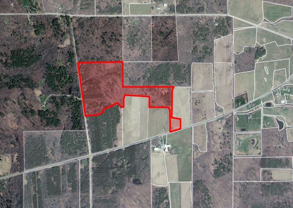
CLU Boundaries in Ag-Analytics FarmScope.


Click the Jupyter Notebook Static Sample to view a static rendition of this APIs Jupyter Notebook.
Click the Jupyter Notebook Github Repo to access the Jupyter Notebook .ipynb files and
instructions needed in order to run this APIs Jupyter Notebook.
Request Parameters
| Parameter | Data Type | Required? | Default | Options | Description |
|---|---|---|---|---|---|
| geometry | string | Yes | -- | Spatial Coordinates (xmin, ymin, xmax, ymax, lat/long coordinates & wkid spatialReference) | The geometry to apply as the spatial filter. The structure of the geometry is the same as the structure of the json/geojson |
| f | string | Yes | -- | geojson/json format | Format of returned data |
Response Parameters
| Parameter | Data Type | Description |
|---|---|---|
| type | String (GeoJSON Object) | Describes the geojson object type (Point, Feature, FeatureCollection) |
| crs | List | Coordinate reference system (EPSG codes) |
| features | List | Container for all the features of the raster |
| features.id | number | Feature object common identifier |
| features.geometry | GeoJSON feature object | Represents spatially bounded points, curves, and surfaces in coordinate space (Polygon, Point, etc.) |
| features.properties | List | List of properties assigned to the spatially bounded feature (Here OBJECTID is the common identifier, CALCACRES is the acreage) |
Boundary Count By State
| State |
State FIPS |
Total Acres |
Boundary Count |
|---|---|---|---|
| Arizona |
4 |
528,832 |
33,917 |
| Arkansas |
5 |
6,080,673 |
254,254 |
| California |
6 |
13,396,334 |
212,539 |
| Colorado |
8 |
19,579,683 |
211,719 |
| Connecticut |
9 |
531,976 |
59,321 |
| Delaware |
10 |
533,347 |
39,968 |
| Georgia |
13 |
8,705,326 |
751,898 |
| Hawaii |
15 |
1,611,910 |
10,512 |
| Idaho |
16 |
10,732,363 |
383,671 |
| Illinois |
17 |
25,372,970 |
1,482,605 |
| Indiana |
18 |
14,093,068 |
753,056 |
| Iowa |
19 |
26,580,471 |
1,380,415 |
| Kansas |
20 |
43,326,372 |
1,142,617 |
| Kentucky |
21 |
10,264,908 |
957,171 |
| Louisiana |
22 |
7,248,373 |
222,710 |
| Maine |
23 |
2,373,594 |
127,727 |
| Maryland |
24 |
2,849,453 |
203,967 |
| Massachusetts |
25 |
547,786 |
45,412 |
| Michigan |
26 |
4,006,083 |
195,718 |
| Minnesota |
27 |
22,442,920 |
875,986 |
| Mississippi |
28 |
1,649,422 |
95,411 |
| Missouri |
29 |
29,821,742 |
1,899,246 |
| Montana |
30 |
50,721,906 |
658,292 |
| Nebraska |
31 |
36,676,731 |
645,104 |
| Nevada |
32 |
1,672,609 |
23,266 |
| New Hampshire |
33 |
894,481 |
33,972 |
| New Jersey |
34 |
952,435 |
77,706 |
| New York |
36 |
9,490,409 |
549,223 |
| North Carolina |
37 |
13,146,229 |
1,194,191 |
| North Dakota |
38 |
32,140,089 |
872,467 |
| Ohio |
39 |
14,995,390 |
983,316 |
| Oklahoma |
40 |
29,320,352 |
733,846 |
| Oregon |
41 |
13,212,207 |
199,824 |
| Pennsylvania |
42 |
7,445,215 |
470,518 |
| Rhode Island |
44 |
72,680 |
7,486 |
| South Carolina |
45 |
2,897,836 |
182,273 |
| South Dakota |
46 |
36,605,108 |
624,934 |
| Tennessee |
47 |
14,462,059 |
1,165,303 |
| Texas |
48 |
123,069,000 |
1,326,269 |
| Utah |
49 |
4,941,516 |
87,729 |
| Vermont |
50 |
1,544,910 |
131,722 |
| Virginia |
51 |
14,283,368 |
821,230 |
| Washington |
53 |
6,000,411 |
183,964 |
| West Virginia |
54 |
2,843,839 |
171,781 |
| Wisconsin |
55 |
15,227,478 |
959,647 |
| Wyoming |
56 |
18,996,788 |
82,021 |
| Total |
|
703,890,650 |
23,525,924 |
Call API
Request
Request URL
Request parameters
-
The geometry to apply as the spatial filter.
-
json, geojson
Request headers
-
string
Request body
Responses
200 OK
Code samples
@ECHO OFF

curl -v -X GET "https://ag-analytics.azure-api.net/CommonLandUnitBoundary/get?geometry={"xmin":-89.6484375,"ymin":40.245991504199026,"xmax":-89.62646484375,"ymax":40.26276066437183,"spatialReference":{"wkid":4326}}&f=json"
-H "Ocp-Apim-Subscription-Key: {subscription key}"

--data-ascii "{body}"
using System;
using System.Net.Http.Headers;
using System.Text;
using System.Net.Http;
using System.Web;

namespace CSHttpClientSample
{
    static class Program
    {
        static void Main()
        {
            MakeRequest();
            Console.WriteLine("Hit ENTER to exit...");
            Console.ReadLine();
        }

        static async void MakeRequest()
        {
            var client = new HttpClient();
            var queryString = HttpUtility.ParseQueryString(string.Empty);

            // Request headers
            client.DefaultRequestHeaders.Add("Ocp-Apim-Subscription-Key", "{subscription key}");

            // Request parameters
            queryString["geometry"] = "{"xmin":-89.6484375,"ymin":40.245991504199026,"xmax":-89.62646484375,"ymax":40.26276066437183,"spatialReference":{"wkid":4326}}";
            queryString["f"] = "json";
            var uri = "https://ag-analytics.azure-api.net/CommonLandUnitBoundary/get?" + queryString;

            var response = await client.GetAsync(uri);
        }
    }
}
// // This sample uses the Apache HTTP client from HTTP Components (http://hc.apache.org/httpcomponents-client-ga/)
import java.net.URI;
import org.apache.http.HttpEntity;
import org.apache.http.HttpResponse;
import org.apache.http.client.HttpClient;
import org.apache.http.client.methods.HttpGet;
import org.apache.http.client.utils.URIBuilder;
import org.apache.http.impl.client.HttpClients;
import org.apache.http.util.EntityUtils;
public class JavaSample
{
public static void main(String[] args)
{
HttpClient httpclient = HttpClients.createDefault();
try
{
URIBuilder builder = new URIBuilder("https://ag-analytics.azure-api.net/CommonLandUnitBoundary/get");
builder.setParameter("geometry", "{"xmin":-89.6484375,"ymin":40.245991504199026,"xmax":-89.62646484375,"ymax":40.26276066437183,"spatialReference":{"wkid":4326}}");
builder.setParameter("f", "json");
URI uri = builder.build();
HttpGet request = new HttpGet(uri);
request.setHeader("Ocp-Apim-Subscription-Key", "{subscription key}");
// Request body
StringEntity reqEntity = new StringEntity("{body}");
request.setEntity(reqEntity);
HttpResponse response = httpclient.execute(request);
HttpEntity entity = response.getEntity();
if (entity != null)
{
System.out.println(EntityUtils.toString(entity));
}
}
catch (Exception e)
{
System.out.println(e.getMessage());
}
}
}
<!DOCTYPE html>
<html>
<head>
    <title>JSSample</title>
    <script src="http://ajax.googleapis.com/ajax/libs/jquery/1.9.0/jquery.min.js"></script>
</head>
<body>

<script type="text/javascript">
    $(function() {
        var params = {
            // Request parameters
            "geometry": "{"xmin":-89.6484375,"ymin":40.245991504199026,"xmax":-89.62646484375,"ymax":40.26276066437183,"spatialReference":{"wkid":4326}}",
            "f": "json",
        };

        $.ajax({
            url: "https://ag-analytics.azure-api.net/CommonLandUnitBoundary/get?" + $.param(params),
            beforeSend: function(xhrObj){
                // Request headers
                xhrObj.setRequestHeader("Ocp-Apim-Subscription-Key","{subscription key}");
            },
            type: "GET",
            // Request body
            data: "{body}",
        })
        .done(function(data) {
            alert("success");
        })
        .fail(function() {
            alert("error");
        });
    });
</script>
</body>
</html>
#import <Foundation/Foundation.h>

int main(int argc, const char * argv[])
{
    NSAutoreleasePool * pool = [[NSAutoreleasePool alloc] init];

    NSString* path = @"https://ag-analytics.azure-api.net/CommonLandUnitBoundary/get";
    NSArray* array = @[
                         // Request parameters
                         @"entities=true",
                         @"geometry={"xmin":-89.6484375,"ymin":40.245991504199026,"xmax":-89.62646484375,"ymax":40.26276066437183,"spatialReference":{"wkid":4326}}",
                         @"f=json",
                      ];

    NSString* string = [array componentsJoinedByString:@"&"];
    path = [path stringByAppendingFormat:@"?%@", string];

    NSLog(@"%@", path);

    NSMutableURLRequest* _request = [NSMutableURLRequest requestWithURL:[NSURL URLWithString:path]];
    [_request setHTTPMethod:@"GET"];
    // Request headers
    [_request setValue:@"{subscription key}" forHTTPHeaderField:@"Ocp-Apim-Subscription-Key"];
    // Request body
    [_request setHTTPBody:[@"{body}" dataUsingEncoding:NSUTF8StringEncoding]];

    NSURLResponse *response = nil;
    NSError *error = nil;
    NSData* _connectionData = [NSURLConnection sendSynchronousRequest:_request returningResponse:&response error:&error];

    if (nil != error)
    {
        NSLog(@"Error: %@", error);
    }
    else
    {
        NSError* error = nil;
        NSMutableDictionary* json = nil;
        NSString* dataString = [[NSString alloc] initWithData:_connectionData encoding:NSUTF8StringEncoding];
        NSLog(@"%@", dataString);

        if (nil != _connectionData)
        {
            json = [NSJSONSerialization JSONObjectWithData:_connectionData options:NSJSONReadingMutableContainers error:&error];
        }

        if (error || !json)
        {
            NSLog(@"Could not parse loaded json with error:%@", error);
        }

        NSLog(@"%@", json);
        _connectionData = nil;
    }

    [pool drain];

    return 0;
}
<?php
// This sample uses the Apache HTTP client from HTTP Components (http://hc.apache.org/httpcomponents-client-ga/)
require_once 'HTTP/Request2.php';

$request = new Http_Request2('https://ag-analytics.azure-api.net/CommonLandUnitBoundary/get');
$url = $request->getUrl();

$headers = array(
    // Request headers
    'Ocp-Apim-Subscription-Key' => '{subscription key}',
);

$request->setHeader($headers);

$parameters = array(
    // Request parameters
    'geometry' => '{"xmin":-89.6484375,"ymin":40.245991504199026,"xmax":-89.62646484375,"ymax":40.26276066437183,"spatialReference":{"wkid":4326}}',
    'f' => 'json',
);

$url->setQueryVariables($parameters);

$request->setMethod(HTTP_Request2::METHOD_GET);

// Request body
$request->setBody("{body}");

try
{
    $response = $request->send();
    echo $response->getBody();
}
catch (HttpException $ex)
{
    echo $ex;
}

?>
########### Python 2.7 #############
import httplib, urllib, base64
headers = {
# Request headers
'Ocp-Apim-Subscription-Key': '{subscription key}',
}
params = urllib.urlencode({
# Request parameters
'geometry': '{"xmin":-89.6484375,"ymin":40.245991504199026,"xmax":-89.62646484375,"ymax":40.26276066437183,"spatialReference":{"wkid":4326}}',
'f': 'json',
})
try:
conn = httplib.HTTPSConnection('ag-analytics.azure-api.net')
conn.request("GET", "/CommonLandUnitBoundary/get?%s" % params, "{body}", headers)
response = conn.getresponse()
data = response.read()
print(data)
conn.close()
except Exception as e:
print("[Errno {0}] {1}".format(e.errno, e.strerror))
####################################
########### Python 3.2 #############
import http.client, urllib.request, urllib.parse, urllib.error, base64
headers = {
# Request headers
'Ocp-Apim-Subscription-Key': '{subscription key}',
}
params = urllib.parse.urlencode({
# Request parameters
'geometry': '{"xmin":-89.6484375,"ymin":40.245991504199026,"xmax":-89.62646484375,"ymax":40.26276066437183,"spatialReference":{"wkid":4326}}',
'f': 'json',
})
try:
conn = http.client.HTTPSConnection('ag-analytics.azure-api.net')
conn.request("GET", "/CommonLandUnitBoundary/get?%s" % params, "{body}", headers)
response = conn.getresponse()
data = response.read()
print(data)
conn.close()
except Exception as e:
print("[Errno {0}] {1}".format(e.errno, e.strerror))
####################################require 'net/http'
uri = URI('https://ag-analytics.azure-api.net/CommonLandUnitBoundary/get')
query = URI.encode_www_form({
# Request parameters
'geometry' => '{"xmin":-89.6484375,"ymin":40.245991504199026,"xmax":-89.62646484375,"ymax":40.26276066437183,"spatialReference":{"wkid":4326}}',
'f' => 'json'
})
if query.length > 0
if uri.query && uri.query.length > 0
uri.query += '&' + query
else
uri.query = query
end
end
request = Net::HTTP::Get.new(uri.request_uri)
# Request headers
request['Ocp-Apim-Subscription-Key'] = '{subscription key}'
# Request body
request.body = "{body}"
response = Net::HTTP.start(uri.host, uri.port, :use_ssl => uri.scheme == 'https') do |http|
http.request(request)
end
puts response.body